Time in Greece: 13:50

Suggested Destinations
- Hotels in Athens
- Hotels in Elounda
- Hotels in Mykonos
- Hotels in Chalkidiki
- Hotels in Corfu
- Hotels in Rhodes
- Hotels in Santorini
- Hotels in Peloponnese
- Hotels in Cyprus
- Hotels in Turkey
- Hotels in U.A. Emirates
Several Categories
- Hotels Worldwide
- Conference Centres
- Hot Deals
- Exclusive Cars
- Limo Service & Luxury Cars
- Transfers

- Planes / Jets
- Helicopters
- Cruises
- Yachts
- Xero Defy Gravity
Area Information
- Info About Athens
- Info About Elounda
- Info About Mykonos
- Info About Chalkidiki
- Info About Corfu
- Info About Rhodes
- Info About Santorini
- Info About Peloponnese
- Info About Cyprus
- Info About Turkey
- Info About U.A. Emirates
Useful Links
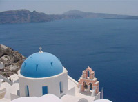
Info About Santorini - Best Luxury Hotels Worldwide
Santorini (Greek Σαντορίνη) is a small, circular group of volcanic islands located in the Aegean Sea, about 200 km south-east from the mainland of Greece (latitude: 36.40°N - longitude: 25.40°E). It is also known by the name of the largest island in the archipelago, Thira or Thera (Θήρα).
It is the southernmost member of the Cyclades group of islands, with an area of approximately 73 km² (28 sq mi), and in 2001 had an estimated population of 13,600. Its spectacular natural beauty along with its eminent nightlife make the island one of Europe's top tourist hotspots.
It is the most active volcanic centre in the Aegean Arc, though what remains today is largely a caldera. The name Santorini was given to it by the Venetians in the 13th century and is a reference to Saint Irene.
Before then it was called Kallistē ('the most beautiful one'), Strongylē ('the circular one'), or Thera. The island was the site of one of the largest volcanic eruptions of the last several thousand years when it erupted cataclysmically about 3,500 years ago.
The eruption left a large caldera surrounded by volcanic ash deposits hundreds of feet deep, and its effects may have indirectly led to the collapse of the Minoan civilization on the island of Crete, 110 km (70 mi) to the south.
"Minoan" Akrotiri
Excavations starting in 1967 at the site called Akrotiri under the late Prof. Spyridon Marinatos have made Thera the best-known "Minoan" site outside of Crete, the homeland of the culture. The island was not called Thera at the time. Only the southern tip of a large town has been uncovered, yet it has revealed complexes of multi-level buildings, streets and squares, with remains of walls standing as high as 8 meters, all entombed in the solidified ash of the famous eruption of Thera. The site was not a palace-complex such as are found in Crete, but its excellent masonry and fine wall-paintings show that this was no conglomeration of merchants' warehousing either. A loom-workshop suggests organized textile weaving for export.
The oldest signs of human settlement are Late Neolithic (4th millennium BC or earlier), but ca 2000–1650 BC Akrotiri developed into one of the Aegean's major Bronze Age ports, with recovered objects that had come not just from Crete but also from Anatolia, Cyprus, Syria and Egypt, from the Dodecanese and the Greek mainland.
Pipes with running water and water closets found on Thera are the oldest such utilities discovered. The pipes run in twin systems, indicating that the Therans used both hot and cold water supplies. The hot water's origin was probably geothermic, given the volcano's proximity.
Fragmentary wall-paintings at Akrotiri lack the insistent mythological content familiar in both Greek and Christian decor. Instead, the Minoan frescoes depict "Saffron-Gatherers", who offer their crocus-stamens to a seated lady, perhaps a goddess; in another house two antelopes, painted with a kind of confident, flowing decorative, calligraphic line; the famous fresco of a fisherman with his double strings of fish strung by their gills; the flotilla of pleasure boats, accompanied by leaping dolphins, where ladies take their ease in the shade of light canopies.
Ancient volcanic eruption
The devastating volcanic eruption of Thira has become the most famous single event in the Aegean before the fall of Troy. The eruption would likely have caused a significant climate upset for the eastern Mediterranean region. It was one of the biggest volcanic eruptions on Earth in the last few thousand years.
Physical effects
The violent eruption was centred on a small island just north of the existing island of Nea Kameni in the centre of the caldera. The caldera itself was formed several hundred thousand years ago by collapse of the centre of a circular island caused by the emptying of the magma chamber during an eruption. It has been filled several times by ignimbrite since then and the process repeated, most recently 21,000 years ago.
The northern part of the caldera was refilled by the volcano and then collapsed again during the Minoan eruption. Before the Minoan eruption, the caldera formed a nearly continuous ring with the only entrance between the tiny island of Aspronisi and Thera. The eruption destroyed the sections of the ring between Aspronisi and Therasia, and between Therasia and Thera, creating two new channels.
On Santorini, there is a deposit of white tephra thrown from the eruption; it is up to 60 metres thick overlying the soil marking the ground level before the eruption. The layer is divided into three fairly distinct bands indicating different phases of the eruption.
Dating
The Minoan eruption provides a fixed point for aligning the entire chronology of the 2nd millennium in the Aegean, because evidence of the eruption occurs throughout the region; however, its exact date is unknown. Current opinion based on radiocarbon dating indicates that the eruption occurred between about 1650 and 1600 BC. These dates, however, conflict with the usual date from archaeology, which is between about 1500 BC and 1450 BC.
Some scholars believe the radiocarbon dates to be completely wrong. Some suggest re-scaling archaeological chronologies with the radiocarbon dates. Others look for a compromise between the archaeological and radiocarbon dates for best fits of both sets of data. Re-scaling archaeological chronologies is controversial, because revising the Aegean Bronze Age chronology could require, by association, revising the well-established conventional Egyptian chronology. The debate about the date continues.
Greek, Byzantine and Ottoman Santorini
Over the following centuries, first Phoenicians, then Dorians, came to control the island.
Thera, the main Hellenic city of the island, on Mesa Vouno, 396 m above sea level was founded in the 9th century BC by Dorian colonists whose leader was Theras, according to tradition, and continued to be inhabited until the early Byzantine period.
According to Herodotus (4.149-165), following a drought of seven years, Thera sent out colonists who founded a number of cities in northern Africa, including Cyrene. As with other Greek territories, Santorini then was ruled by the Romans, the Byzantines, and the Franks. The island came under Ottoman rule in 1579.
Greek, Byzantine and Ottoman Santorini
Santorini was annexed to Greece in 1912. Major settlements in Santorini include Fira (Phira), Oia, Emporio, Kamari, Imerovigli, Pyrgos and Therasia. Akrotiri is a major archaeological site with ruins from the Minoan era. The island has no rivers and water is scarce. Until the early nineties locals used to fill water cisterns from the rain that fell on their roofs and courts, from small springs as well as by importing it from other areas of Greece. Nowadays, there is a desalination plant that provides running, yet nonpotable, water to most houses. The primary industry of Santorini is tourism. The pumice quarries have been closed since 1986 in order to preserve the caldera of Santorini.
Santorini is home to a small but flourishing wine industry, based on the indigenous grape variety, Assyrtiko. Assyrtiko vines are extremely old, as they are resistant to phylloxera and have consequently not needed to be replaced during the great phylloxera epidemic of the early 20th century. They are adopted to their native habitat by being planted far apart and their principal source of moisture is dew. They are trained in the shape of baskets, with the grapes hanging inside to protect them from the winds. Also unique is the red, sweet and extremely strong Vinsanto.
In 1707 an undersea volcano breached the sea surface forming the current centre of activity at Nea Kameni, and eruptions centred on it continue—three times in the twentieth century, the last being in 1950. Santorini was also struck by a devastating earthquake in 1956. At some time in the future, it will undoubtedly erupt violently again.